
Seen Here: Geospatial Intelligence Solutions (NTG) is demonstrating how GIS technology can transform municipal cemetery management by digitising burial records, mapping grave locations, preserving historical information and equipping municipalities with better tools for operational efficiency and future infrastructure planning. Photo Credit: Supplied
NTG Solutions develops a digital cemetery management system designed to help municipalities modernise burial records, preserve historical information, improve operational efficiency and plan for future burial-space demands.
JOHANNESBURG – In every cemetery lies a record of human lives, family histories and community heritage. Yet, for many municipalities, preserving that history while managing the practical demands of public cemeteries remains an increasingly complex responsibility.
Ageing paper registers, incomplete burial records, outdated cemetery layouts and fragmented administrative systems can make it difficult to locate graves, verify historical information and determine how much burial space remains available.
For families searching for the final resting place of a loved one, these administrative shortcomings can turn an already emotional experience into a frustrating process. For municipal officials, they create operational challenges that can affect service delivery, infrastructure planning and the preservation of important public records.
NTG Solutions is seeking to address these challenges through a Geographic Information Systems (GIS)-based Cemetery Management System, a digital solution that brings spatial information, burial administration and cemetery operations together within a single environment.
The system demonstrates how geospatial technology can move beyond conventional digital mapping to help municipalities make better-informed decisions about the land, records and communities entrusted to their care.
Commenting on the thinking behind the initiative, NTG Solutions Managing Director Nyawa Dikwayo says cemetery records form an important part of municipal institutional knowledge and should be managed accordingly.
“Municipalities are custodians of important community information, and cemetery records are part of that responsibility. Yet, much of this information has historically been managed through fragmented, paper-based processes, making it difficult to maintain accurate records, access information and plan effectively,” says Dikwayo.
“At NTG Solutions, we believe geospatial technology should do more than help us understand places; it should help organisations make better decisions about the spaces and communities they serve. The Cemetery Management System demonstrates how we can bring location intelligence and operational information together to address a practical municipal challenge.”

Seen Here: NTG Solutions Managing Director Nyawa Dikwayo is championing the use of geospatial technology to modernise cemetery management, preserve historical burial records and strengthen municipal service delivery through a GIS-based digital solution. Photo Credit: Supplied
Beyond a digital map: Building a connected cemetery management system
At the centre of the solution is GIS technology, which connects cemetery information to specific geographical locations.
Rather than simply displaying cemetery boundaries and grave positions, the system integrates several administrative and operational functions, including cemetery layouts, burial applications, grave allocations, burial records, maintenance activities, historical record verification, exhumations and management reporting.
Cemeteries can be organised into sections, blocks, lots and individual graves, enabling authorised municipal officials to identify burial locations, retrieve associated records and establish whether graves are occupied, reserved or available.
The platform also supports the administration of the burial process, from receiving applications and supporting documentation to allocating graves and recording completed burials.
Different application categories are accommodated, including new burials, re-openings, cremations and exhumations.
Importantly, the system is designed to maintain continuity of records when burial circumstances change. Where remains are exhumed and subsequently reinterred, the original burial information can be retained alongside details of the exhumation and new burial location.
This creates a more comprehensive record of each site’s history, strengthening traceability and reducing the risk of important information being lost through fragmented record-keeping.
Protecting identity and preserving historical records
One of the most significant opportunities presented by digital cemetery management is the preservation and verification of historical burial information.
In many municipalities, older records remain confined to handwritten registers, archived documents and legacy spreadsheets. Over time, these records may become damaged, incomplete or difficult to reconcile with existing cemetery layouts.
Digitising such information is an important first step, but it does not automatically make historical records accurate.
NTG Solutions has incorporated a verification component that distinguishes between records that have been digitised and those that have undergone verification. This allows municipal officials to identify information requiring further investigation and progressively improve the reliability of their digital records.
The distinction is particularly important when dealing with unidentified deceased persons and specialised burial arrangements.
The system accommodates Hopa burials, involving unidentified deceased persons, where multiple individuals may be buried within a designated site. It distinguishes between the overall burial location and the individual records associated with each person.
Through a dedicated registration process, officials can capture forensic references, Death Register (DR) numbers, identification status and subsequent exhumation details against individual records.
This creates an important information trail should an unidentified person later be identified, potentially helping preserve details that could be significant to families, authorities and future investigations. It also reinforces a fundamental principle of public cemetery management: the responsibility extends beyond maintaining burial land. It includes protecting human dignity, preserving identity and ensuring that information remains accessible when it is needed.
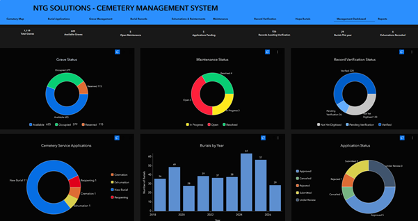
Seen Here: The NTG Solutions Cemetery Management System Dashboard provides municipal officials with a consolidated view of cemetery operations, including grave availability, burial applications, burial records, maintenance activities and historical record verification. The GIS-powered platform supports informed decision-making, improved administrative efficiency and more effective planning of municipal cemetery infrastructure. Photo Credit: Supplied
Improving municipal operations and infrastructure planning
The system’s value also extends into the day-to-day management of cemetery infrastructure.
Its maintenance register enables municipalities to record and monitor operational issues such as overgrown vegetation, damaged grave markers, access routes and other infrastructure concerns.
These records can be linked to individual graves or broader cemetery areas, allowing officials to identify maintenance requirements and track where intervention is needed.
Mobile field workflows further support inspections and record-verification activities, including in environments where internet connectivity may be limited.
For municipal management, the platform brings together operational information through a dashboard featuring indicators covering grave availability, burial activity, applications, maintenance and record-verification progress.
Six operational registers support the management of burials, Hopa burials, exhumations and reinterments, maintenance, record verification and applications.
Officials can search, filter and export information to support administrative reporting, operational oversight and management decisions.
This level of visibility is particularly relevant as municipalities face increasing pressure to manage limited public land and plan for future service requirements.
In areas where available burial space is becoming constrained, reliable spatial information can help municipalities establish existing capacity, identify potential limitations and assess future land and infrastructure requirements.
Although digital mapping cannot create additional burial land, it can give municipalities a clearer understanding of how existing space is being used and where more responsible planning is required.
Bringing cemetery information closer to communities
Beyond internal municipal operations, the solution also introduces the concept of a public-facing cemetery viewer.
The proposed functionality is intended to demonstrate how selected cemetery information and services could become more accessible to residents.
Potential features include searching for the grave of a loved one, accessing burial-related services and viewing approved memorial information.
Public access would, however, remain subject to municipal approval, privacy requirements and appropriate information-verification procedures.
For families, the ability to locate a loved one’s final resting place through an accessible digital platform could significantly simplify cemetery visits and reduce the administrative burden associated with obtaining burial information.
For municipalities, it could provide an additional channel for responding to public enquiries while improving access to approved information.
A new opportunity for smarter municipal service delivery
Developed as a functional prototype, the NTG Solutions Cemetery Management System illustrates how GIS, digital applications, operational workflows and management reporting can be integrated to address a longstanding municipal challenge.
The next phase towards municipal implementation would require validation of existing records, confirmation of operational requirements, configuration of user permissions and the integration or automation needed to accommodate individual municipal environments.
Its broader significance lies in demonstrating how geospatial technology can support public-sector functions that are often overlooked in conversations about digital transformation.
While GIS is commonly associated with land administration, infrastructure and spatial planning, its application in cemetery management highlights the technology’s potential to improve public asset management, preserve institutional knowledge and strengthen municipal accountability.
Ultimately, modernising cemetery management is about more than replacing paper registers with digital records. It is about ensuring that municipalities can account for the spaces they manage, preserve the histories entrusted to them and provide communities with more accessible and responsive services.
As Dikwayo’s vision suggests, technology should serve a purpose beyond innovation itself. In this case, that purpose is ensuring that the stories associated with every burial are not lost to administrative inefficiency, but remain part of the institutional and community history that future generations deserve to inherit.
#NTGSolutions #CemeteryManagementSystem #GISTechnology #GeospatialIntelligence #DigitalTransformation #MunicipalInnovation #SmartMunicipalities #DataDrivenDecisions #PublicSectorTechnology #SouthAfrica